 WILD BLUE MEDIA/CHANNEL 4
Researchers have found more than 60,000 hidden Mayan ruins in Guatemala in a major archaeological breakthrough.
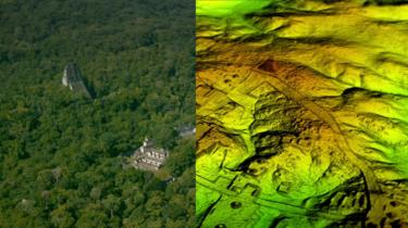
Laser technology was used to survey digitally beneath the forest canopy, revealing houses, palaces, elevated highways, and defensive fortifications.
The landscape, near already-known Mayan cities, is thought to have been home to millions more Mayans than other research had previously suggested.
The researchers mapped over 810 square miles (2,100 sq km) in northern Peten.
 WILD BLUE MEDIA/CHANNEL 4
Results from the research using "revolutionary" Lidar technology, which is short for "light detection and ranging", suggest that Central America supported an advanced civilisation more akin to sophisticated cultures like ancient Greece or China, National Geographic reports.
"The Lidar images make it clear that this entire region was a settlement system whose scale and population density had been grossly underestimated," Thomas Garrison, an Ithaca College archaeologist, told the magazine.
Revolutionary technology
Described as "magic" by some archaeologists, Lidar is unveiling archaeological finds almost invisible to the naked eye.
The group of scholars who worked on this project beamed laser pulses at the ground from a plane and measured the wavelengths as they bounced back, which is not unlike how bats use sonar to hunt.
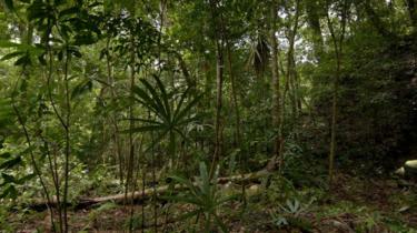
Lidar enabled them to digitally remove the tree canopy and create a detailed three-dimensional image of what is really under the surface of the now-uninhabited landscape.
"Lidar is revolutionising archaeology the way the Hubble Space Telescope revolutionised astronomy," Francisco Estrada-Belli, a Tulane University archaeologist, told National Geographic. "We'll need 100 years to go through all [the data] and really understand what we're seeing."
 WILD BLUE MEDIA/CHANNEL 4
Archaeologists excavating a Maya site called El Zotz in northern Guatemala, painstakingly mapped the landscape for years. But the Lidar survey revealed a 30-foot-long (9m) fortification wall that the team had never noticed before.
"Maybe, eventually, we would have gotten to this hilltop where this fortress is, but I was within about 150 feet of it in 2010 and didn't see anything," Maya expert Tom Garrison told Live Science.
In recent years Lidar technology has also been used to reveal previously hidden cities near the iconic ancient temple of Angkor Wat in Cambodia.
- How lasers revealed a lost city in the Cambodian jungle
- 'Mayan day of apocalypse' marked
- Radio 4's In Our Time: The Maya Civilisation
Hidden insights
Mayan civilisation, at its peak some 1,500 years ago, covered an area about twice the size of medieval England, with an estimated population of around five million.
"With this new data it's no longer unreasonable to think that there were 10 to 15 million people there," said Mr Estrada-Belli, "including many living in low-lying, swampy areas that many of us had thought uninhabitable."
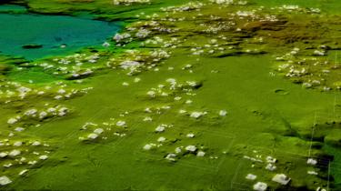
Most of the 60,000 newly identified structures are thought to be stone platforms that would have supported the average pole-and-thatch Mayan home.
One of the hidden finds is a seven-storey pyramid so covered in vegetation that it practically melts into the jungle.
 WILD BLUE MEDIA/CHANNEL 4
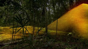 WILD BLUE MEDIA/CHANNEL 4
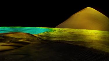 WILD BLUE MEDIA/CHANNEL 4
A discovery that surprised archaeologists was the complex network of causeways linking all the Mayan cities in the area. The raised highways, allowing easy passage even during rainy seasons, were wide enough to suggest they were heavily trafficked and used for trade.
The Lidar survey was the first part of a three-year project led by a Guatemalan organisation that promotes cultural heritage preservation. It will eventually map more than 5,000 sq miles (14,000 sq km) of Guatemala's lowlands.
The project's discoveries will feature in a Channel 4 programme called Lost Cities of the Maya: Revealed, airing in the UK on Sunday 11 February at 20:00 GMT.
No comments:
Post a Comment